Final Analysis of the Location of the River Astræus
The Astræus candidates
In our previous paper (1), presented on the pages of The American Fly Fisher, we reviewed literature published to date about the possible present-day rivers that might be the Astræus, a river where fly fishing was recorded for the first time by Ælian, Roman author (2). The choice of possible rivers was reduced to just two: the Koutichas and the Arapitsas – rivers in Northern Greece near the city of Naousa, some 70 km from Thessalonica. It is, of course, impossible to be completely confident in this issue, since the data about it are scarce and unreliable, but this time we will try to further investigate the problem from various angles and give some answers.
Ælian briefly described the position of the Astræus as “Between Berœa (3) and Thessalonica”. However, just by looking at the map it is obvious that the direct line between Thessalonica and Veria does not cross a river where fly fishing for trout was possible. There are three rivers there: the Gallikos, known in ancient times as the Echedorus (4), the Axios and the Loudias (Map 1). They are slow moving muddy lowland rivers (the Loudias is actually a canal), which never supported trout. This fact alone would be enough to discard them as possible candidates for the Astræus, but there is more evidence to confirm that theory. First of all is that in Ælian’s time (170-230 A.D.) those rivers were already well known under their names. The Axios was mentioned by Herodotus (5), Strabo (6), Plinius Secundus (7), Apollodorus (8) and Ptolemy (9). The Loudias (10) was also mentioned by Herodotus and Strabo, while Echedorus was known from Strabo and Greek mythology (11), as a river visited by Heracles.

Map 1. Contemporary situation in the area. Numbered rivers are: 1.Gallikos, 2. Axios, 3. Loudias, 4. Haliacmon, 5. Regional Canal, 6. Arapitsas, 7. Koutichas
There is one more river in the area also mentioned as possible Astræus candidate – the Haliacmon (12), the longest river of Greece, which drains its waters in the sea not far from Veria. Considering that in its upper reaches this river does support trout it was assumed that it might be the Astræus candidate, although it does not exactly cross the Thessalonica – Veria line.
However, this river was also mentioned under that name in the works of Herodotus, Strabo, and Plinius Secundus. Works of those authors were well known to Ælian. Some were regarded as his direct sources of information and it is very possible to assume that Ælian would have used their names if one of these rivers was the one where he described fly fishing for the first time. What is more, Axios (13) and Haliacmon (14) were also well known as river gods in the Greek mythology, which further reduces the odds that either of them was the Astræus.
The mere fact that above mentioned rivers do not support trout would be good enough reason to reject them as the Astræus candidates for a fly fisherman. It seems that among professional historians there were no fly fishermen willing to investigate the issue. So, a contact with professor Borza (15), the great authority on Macedonian history yielded an answer that “Ælian may have made an error, confusing the Astræus with the Axios”. With all due respect to professor Borza, who very kindly responded to our questions, we do not hold the view that the Astræus was the Axios, which is why we went so much into details in the previous text. Our opinion is that none of the above mentioned rivers are serious candidates for the Astræus, not only from the literature but also from the visit to the area and direct field investigation.
Hammond’s paper and its effects
In recent years the search for the Astræus was initiated by the short but very comprehensive paper written by Hammond (16). This paper had a strong influence on most recent texts published, including the one we wrote. Apparently it solved the problem, giving that one river, the Arapitsas, was directly denoted as the Astræus. However, the text itself held some inaccuracies and assumptions which led scientists to consider “his attempt to locate the Astræus speculative” (15).
Hammond, although the majority of the information in his paper was correct, made some unintentional errors, which possibly led to the opinion that his conclusions were speculative. A significant problem was a controversy about the Scirtus river, which he wrote was flowing through Edessa, an old Macedonian city, not far from Veria and Thessalonica. That river was also regarded as the Astræus candidate, but it was rejected both by Hammond and us on the basis that “in Ælian’s time this river was known with that name”. The river was identified in a text by Procopius (18), where it was written that “the Scirtus River flooded Edessa, creating countless sufferings among the inhabitants”. However, that river was flooding another place in Mesopotamia, also called Edessa. That other Edessa was placed between the Euphrates and Tigris rivers, and the river Scirtus (“leaping river” in Greek) was flowing through it (19). It was founded as a military settlement by Seleucus I, one of Alexander the Great’s generals. Today the city is in Turkey, it is called Sanli Urfa and the river’s modern name is the Daisan. Procopius referred to the Mesopotamian Edessa and there are other written documents about the great flood that happened there in 201 A.D. (20).
All this leaves us with the question: what was the name of the river that flows through Macedonian Edessa? Today its name is the Edhessaios or the Vodas, but we do not have evidence that this river was also called Scirtus in ancient times. Considering that this river is in a wider area for the Astræus candidates, we now cannot say that it can be rejected on the basis that its name was known in Ælian’s time. Nowadays it is a river rich in clear water, that starts from many springs at the lake of Nisos and which flows through Edessa divided in many branches, finally finding its way out to the plain, failing from a height of 70 meters and creating the famous waterfalls of Edessa. Such a waterfalls could have been a prominent feature to identify the river, had they existed in Ælian’s time, but it seems they did not. Until the end of the 14th century the main volume of the water was held in a small lake in the west of the town. Then the waters, perhaps after a geological phenomenon, started to flow through the town, creating many small rivers and waterfalls. At the same time the small lake disappeared (21). Through an analysis of the available data and his own observations Cvijic (22) explained the process in detail. There were three phases in the development of the waterfalls of Edessa: 1. until the 12th century the river flew below the ground (which is common in limestone formations), 2. from 12th to 14th century the water was accumulated in the lake above Edessa, and 3. after that the waterfalls were created. This helps us to discard the Edhessaios as the Astræus candidate, not because it had different name in the past, but in view of the fact that the river was not there in Ælian’s time.
The other controversy was created by map that covered part of Macedonia published in Hammond’s paper (16). For easy reference we are presenting a section of the map (Map 2), which was published in Hammond’s book: “The Genius of Alexander the Great” (17) . Effectually the author assumed that the Astræus was a tributary of Haliacmon. We will quote Hammond’s original text:
“…the Astræus entered the Haliacmon in the time of Herodotus… As regards recent times, a map of 1928 showed in the centre of the plain a large lake (that of Yannitsa) into which all the waters flowing from the western foothills found their way through swamps. Thereafter the lake was drained and a “Regional Channel” was made to carry the waters from the western foothills not into the plain, but into the Haliacmon. Because the channel follows the natural lie of the land, it is probably the line of the ancient Astræus. That is where I showed the course of the Astræus in my Atlas of the Greek and Roman World in Antiquity (London 1991) map 12 and in The Miracle That Was Macedonia (London 1991) fig. 2.“ (16)

Map 2. Hammond’s map with the Astraeus as the Haliacmon tributary
This text gave us proof to place the Astræus as the Haliacmon tributary in the reconstructed pictures given in our previous TAFF article on the subject. However, further study of the problem and visit to the area showed that the situation was somewhat different. The natural position of the land in that area never allowed the Haliacmon tributary in the place where it was shown on Map 2. In other words, the Regional Channel did not “follow the natural lie of the land”. Between the Haliacmon and Veria there is an area of higher ground, formed by eastern slopes of Vermion Mountain, which prevented rivers that flow into present day Regional Channel to enter the Haliacmon. They all flew into the lake near Pella (the Yannitsa Lake) and surrounding swamps. It was shown on various old maps, and possibly the best example was shown on Map 3, based on a chart published by Cvijic (22). That work, possibly the most comprehensive book ever published about geology and geography of Macedonia, clearly showed that at the beginning of 20th century the Haliacmon had no tributaries from the eastern slopes of Mt. Vermion. Based on this information we can conclude that in antiquity essentially the same situation existed, although the size of the lake and swamps and courses of some rivers varied to some extent. This means that the Astræus never crossed the imaginary line “Between Berœa and Thessalonica”, and certainly not in Ælian’s time.
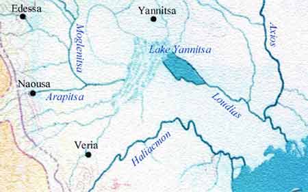
Map 3. Translated Cvijic’s map which shows the situation in 1906
Considering that the three rivers which flow directly between Veria and Thessalonica are as far from trout fly fishing river as can be imagined, we assumed that we have to look for suitable trout rivers close to Veria. Such rivers have high oxygen content, which in this part of Europe means that they are flowing from the mountain. Trout can be found in Greece at altitudes of over 300 meters above sea level. The mountain closest to Veria is the Mt. Vermion. Veria itself is lying on its lower slopes and it was logical to look among the rivers that flow there. The choice was also restricted to the rivers suitable for the ancient fly fishing style portrayed by Ælian.
Locating the Astræus
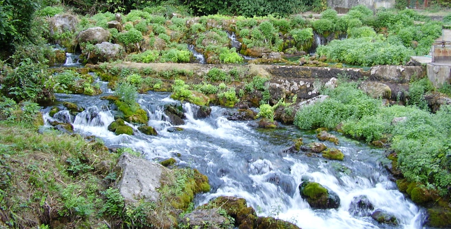
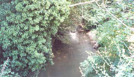
From the research we did for the previous article (1) it was clear that there are two genuine Astræus candidates: the Koutichas and the Arapitsas. Investigation on the ground showed that the Koutichas is a very small rivulet, too small to be serious Astræus candidate (Picture 1). Its rather small and narrow valley also showed that this was never bigger river. However, the Arapitsas (which in Greek means “The Little Black River”), appeared just as the right kind of stream (Pictures 2 & 3). It is obviously a trout river closest to Veria. The Arapitsas is rising from a spring located under a limestone cliff in Agios Nikolaos (Saint Nicholas), a park of nature, some 2 km from Naousa and 20 km from Veria (Map 4). Until Naousa it flows in the east-west direction and than changes its course to the north-western direction, flowing through village of Lefkadia and not far from Kopanos in the lowland Macedonian Plain. After that its waters join the Regional Channel. In Naousa the river forms well known waterfalls. It is a clear and sparkling river that supports trout in most of its flow. Fishing is forbidden there, but there are several trout farms not far from its spring, which clearly shows that this river has a suitable habitat. (Pictures 1-5)

Picture 1. Koutichas

Picture 2: The spring of the Little Black River
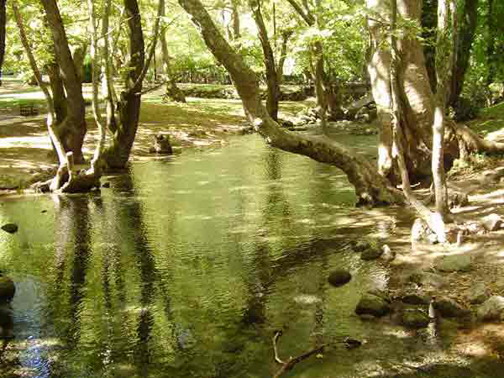
Picture 3. The calm Arapitsas in Agios Nikolaos

Picture 4. The Arapitsas rapids in Agios Nikolaos
Picture 5. The Arapitsas below Naousa near Aristotle’s School
As a conclusion we can say that the Arapitsas is positioned in the area where Astræus may be expected, and that it certainly was a trout river in the past. But also this river is perfectly suited to the type of fly fishing described by Ælian, and without doubt the same situation was in his time. Ælian described fly fishing with a six feet rod and line. From our previous investigation of traditional fly fishing we knew that this form of fly fishing is still possible to see on some rivers on the Balkans (Picture 5). Observation of these fishermen helped us a lot in this investigation. It was very helpful to see what type of water they prefer and generally how they fish. The six feet is a very short rod, but on the right type of water it is possible to successfully fly fish with it. This is why these fishermen prefer small to medium sized rivers with fast and broken water. The Arapitsa is perfectly suited for that ancient fly fishing style, better than any other river in the described area.
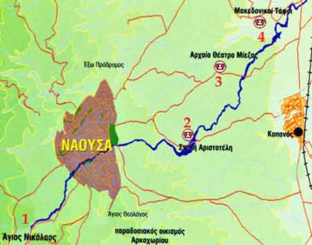
Map 4. Contemporary situation in Naousa with the surrounding area. Numbered places are: 1. Agios Nikolaos, 2. School of Aristotle, 3. ancient theatre, 4. Macedonian tombs
Was it possible that a story about fishing on such a comparatively small river reached Ælian, who lived in distant Rome and never traveled much? From the archaeological investigations and excavations it is obvious that certain important localities existed on the banks of the Arapitsas. A number of Macedonian tombs (tombs of the Palmettes and tomb of “Krisis” at Kopanos, also tomb of Lyson and Kallikles at Lefkadia) were discovered on the lower part of the river (23, 24). Also the ancient theatre at Kopanos with the capacity estimated at 1500 visitors is located there. Quite close to the river, the remnants of a Roman mansion with mosaic floors were discovered. Still, much more important site was placed on the Arapitsas banks – the School of Aristotle (Picture 6), about which at the official presentation of Greek Ministry of Culture (25) was written the following text:

The Sanctuary of the Nymphs (Nymphaion) lies in a magnificent landscape, rich in water and vegetation, at the site called Isvoria, in the vicinity of Naousa. Shortly after the middle of the 4th century B.C., the whole area was properly arranged to house the School where the famous philosopher Aristotle gave lessons of Philosophy, Arts and Mathematics to young Alexander, son of the Macedonian king. In an area between two natural caves, the rock was carved in a rectangle and an Ionic colonnade was added to form a roofed, L-shaped stoa.”
Picture 6. Aristotle’s School at Isvoria
The School is positioned on the left bank of the Arapitsas, near one spring about 3 km from Naousa. In that part the river enters the Macedonian Plain and flows through lush fruit plantations. The area is famous with its vineyards and peach production. The water of the river is still clear and bright and it is very likely that it supports trout even in such a lowland location. The fact that from the age 13 to 16 Alexander actually lived on the Arapitsas bank certainly has significance, everything connected to that great Macedonian monarch, considered by many as the most charismatic and heroic king of all times – became a legend. Hence, we can assume that the river that flew by his school was certainly quite famous in classical times. It pushes our imagination further – the Alexander’s age, while he was there, was just right for him to try fishing. There is no evidence whatsoever about that, but wouldn’t it be the most normal thing that a boy of 13 is interested in fishing?
On the basis of our research and visit to the area, the Arapitsas appears to be the most serious candidate for the Astræus. The following reasons led us to this conclusion: 1. it is a trout river, rather close to Veria, 2. it is suited to the fly fishing style described by Ælian, 3. it was significant river in ancient times. Although, as can be seen from our text, we disagree with Hammond in certain details, we essentially agree with him in general conclusion that, if Ælian’s location of the Astræus was correct, the Arapitsa was almost certainly that river. The river is somewhat changed with human activity. There are several trout farms on the first section of its flow and part of the river was captured for water supply directly on the spring. In the remaining river the native brown trout was replaced with imported rainbow trout. But the Astræus is still there and everyone interested may go and visit it.

Picture 7. Traditional fly fishing with a short hazel rod
